Best Dolomites Viewpoints for an Easy Road Trip
An accessible Dolomites road-trip guide featuring dramatic mountain viewpoints, short walks, practical parking stops, and route-planning advice.
An accessible Dolomites road-trip guide featuring dramatic mountain viewpoints, short walks, practical parking stops, and route-planning advice.
The Dolomites reward careful route planning more than ambitious mileage. Their sharp limestone towers, high passes, green valleys, and small mountain lakes can look close on a map, yet winding roads and frequent photo stops make travel slower than expected. For a first summer road trip, the best plan is not to collect every famous location. It is to choose a compact circuit with several different types of view and enough flexibility for changing mountain weather.
Cortina d’Ampezzo is a practical base for an eastern Dolomites route because several major viewpoints sit within a manageable driving radius. From Cortina, you can reach Passo Tre Croci, Lake Misurina, the Tre Cime area, Passo Giau, and viewpoints over the Ampezzo valley without rebuilding your route each morning. The official Cortina tourism site describes the road toward Tre Cime as a scenic route through meadows, woodland, Passo Tre Croci, and Lake Misurina. That variety is exactly why it works for a view-led itinerary.
Drivers based farther west may prefer Val Gardena or Alta Badia, but mixing the eastern and western Dolomites into one day is usually a poor decision. The distance looks modest, while traffic, hairpin bends, cyclists, parking searches, and roadside stops add time. Give one area a full day and save the next valley for another trip.
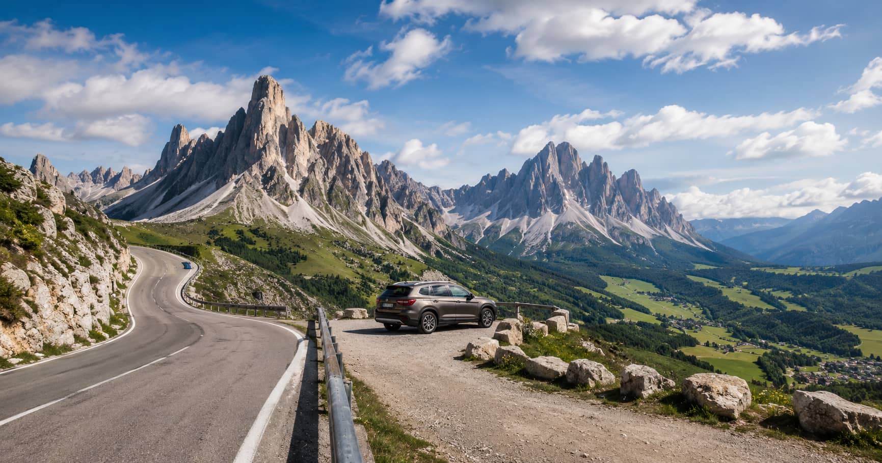
Passo Giau is one of the strongest opening stops because the road climbs directly into a broad mountain setting. The pass gives clear views toward Ra Gusela and surrounding peaks without requiring a long hike. Early morning usually offers calmer conditions, lighter traffic, and side light that gives the rock faces more depth. Evening can also work, but you should not build the whole day around a perfect sunset because cloud can gather quickly around the peaks.
Park only in marked areas and avoid stopping on narrow verges. A useful viewpoint does not justify blocking traffic or damaging alpine grass. Walk a short distance away from the busiest pull-off and use the road, pasture fences, or low ridges as foreground elements. The classic mountain silhouette is easy to photograph; the harder task is showing scale and route context.
Lake Misurina adds water, reflections, and a lower viewpoint to a route dominated by high passes. The lakeside is accessible, so it works well for travelers who do not want every stop to involve a steep climb. On still mornings, the surrounding mountains may reflect in the water. Later in the day, wind often breaks the reflection, but the lake remains useful as a place to slow down, eat, and reassess visibility before driving higher.
Do not spend the whole visit searching for a completely empty lakeshore. In summer, Misurina is active and developed. The visual value comes from the relationship between water, buildings, road access, and mountain walls. A realistic guide should show that this is an easy scenic stop rather than an untouched wilderness location.
Tre Cime di Lavaredo is the visual anchor of the eastern Dolomites, but access requires more planning than a normal roadside viewpoint. Parking controls, shuttle systems, road restrictions, and seasonal demand can change. Check current arrangements before leaving through the official Cortina Dolomites route information and local transport pages. Arriving without checking can turn the most important stop into the least efficient part of the day.
If access is full, visibility is poor, or thunderstorms are developing, do not force the plan. Lake Antorno, Lake Misurina, Passo Tre Croci, and lower valley viewpoints still produce a coherent visual route. Tre Cime is worth seeing, but it should not make every other decision dependent on one crowded location.
You do not need to complete the full Tre Cime circuit to gain a strong sense of the terrain. Shorter walks from the main access area can reveal the north faces, nearby ridges, and changing relationships between the towers. The full circuit is more rewarding for walkers with suitable footwear, water, layers, and time, but a road-trip article should distinguish a viewpoint stop from a mountain hike. Weather, fitness, and trail conditions matter more than a fixed checklist.
Passo Tre Croci is less dramatic than Tre Cime or Passo Giau, yet it improves the route because it connects Cortina with Misurina and opens views toward Sorapiss and the Ampezzo basin. The official Dolomites information places the pass at 1,805 metres and describes the outlook in both directions. It also serves as the starting point for the well-known Lago di Sorapis trail, which the tourism office classifies as a route for experienced walkers because of exposed and equipped sections. That distinction matters: the pass is easy to reach, while the lake hike is not an automatic add-on for casual road trippers.
A sensible route starts with the highest-priority viewpoint under the clearest forecast. If the peaks are visible at dawn, go high early. If cloud sits on the passes but the valleys are open, begin at a lake or lower overlook and wait. Check precipitation, cloud level, wind, and thunderstorm risk rather than looking only at a single weather icon. Mountain conditions can differ sharply from the forecast for the nearest town.
Carry a light waterproof layer even on a warm day, keep water in the car, and leave enough fuel for slow mountain driving. Download maps before entering areas with weak signal. The aim is not to prove that you can complete every stop. It is to return with a varied set of views while avoiding unnecessary risk and backtracking.
For a clear summer day, begin at Passo Giau, return toward Cortina, continue over Passo Tre Croci, pause at Lake Misurina, and then approach the Tre Cime area if access and weather remain suitable. Finish with a lower valley view rather than racing to another distant pass. This sequence provides rock towers, broad pasture, water, road geometry, and a major mountain landmark without crossing the entire Dolomites.
The best Dolomites road trip is rarely the one with the most pins on the map. It is the one that respects slow roads, changing weather, and the difference between an accessible viewpoint and a serious hike. Choose one base, protect time for the strongest stop, and let the route become shorter when conditions demand it.